Temperature—°C◆Air quality—EAQI◆Wind—km/h◆Mondego—m³/s◆
VisitA day on foot

Up to the Alta,
down to the river

Coimbra reads in storeys. Down below, the Baixa and the Mondego; at the top of the hill, the university courtyard; across the bridge, the bank from which the whole Alta can be seen. A day on foot is enough for the 10 stops on this route — if you start at the bottom.

  1. 00 The day on the map
  2. 01 Morning · Up to the Alta
  3. 02 Midday · Down through the garden
  4. 03 Afternoon · Across the river
THE DAY ON THE MAP

10 stops, three parts of the day

In the morning you climb, because climbing is less tiring while the day is cool. You come down through the garden at lunchtime and cross the river in the afternoon, when the sun is on the Alta.

What is your day like?
on foot
4.4 km
of climb
139 m
of steps
240 m
Morning

Up to the Alta

  1. 1Mosteiro de Santa CruzStart down here, beside the first king400 m · 42 m up · 70 m of steps
  2. 2Sé VelhaThrough the Arco de Almedina and up the steps240 m · 32 m up
  3. 3Museu Nacional de Machado de CastroJust above the Sé; go down to the cryptoporticus280 m · 8 m up
  4. 4Paço das EscolasThe top of the hill, through the Porta Férrea100 m
  5. 5Biblioteca JoaninaIn the same courtyard, with a ticket from the university visits550 m · 15 m down
Midday

Down through the garden

  1. 6Aqueduto de São SebastiãoEast of the Alta, at the garden gate120 m · 7 m down · 15 m of steps
  2. 7Jardim BotânicoA long break, if the day is fine1.6 km · 27 m up · 82 m down · 70 m of steps
Afternoon

Across the river

  1. 8Mosteiro de Santa Clara-a-VelhaOver the Ponte de Santa Clara, on the far bank530 m · 20 m of steps
  2. 9Portugal dos PequenitosNext to the monastery, especially with children560 m · 24 m up · 18 m down · 65 m of steps
  3. 10Quinta das LágrimasTo end the day in the gardens

The shortest way on foot, door to door, by the streets and the steps. What you walk inside each place is not counted.

RouteOpenStreetMap · DGT LiDAR (2 m DTM) · 30 Sept 2026
Morning

Up to the Alta

The Baixa · Start down here, beside the first king

Mosteiro de Santa Cruz

On the Praça 8 de Maio, the monastery where the first two kings of Portugal, D. Afonso Henriques and D. Sancho I, are buried. That is why it is a National Pantheon.
Founded in 1131 · National Pantheon since 2003Câmara Municipal de Coimbra →
The Baixa as a model (in Portuguese) →
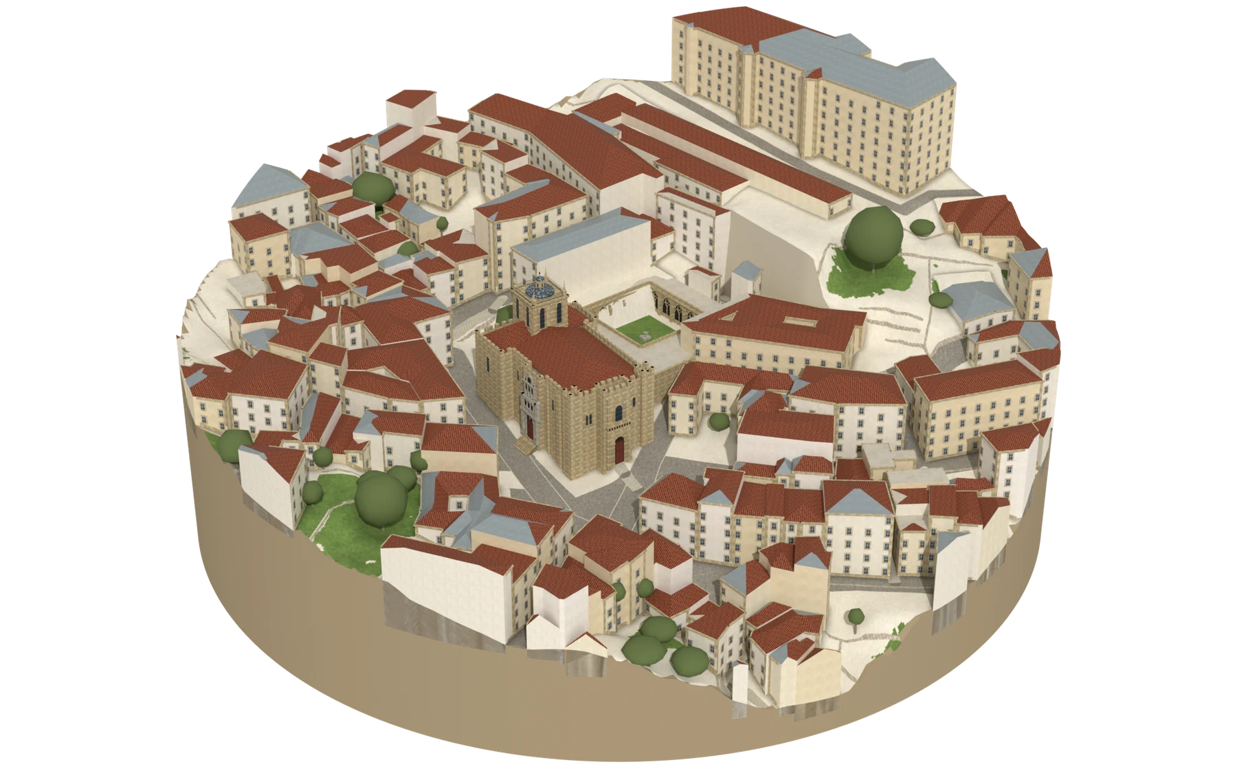
Reconstruction of the Mosteiro de Santa Cruz seen from the Praça 8 de Maio: the church façade between the two towers, the cloister behind and the Fonte da Manga in the background.
  • façades and details: drawn from photographs
  • tile or zinc, as in the aerial photograph
  • streets, squares and gardens: drawn from the map
  • tree
200 m in diameter · façade 22 m high
ModelOpenStreetMap · DGT LiDAR (2 m DTM and DSM) · DGT 2025 orthophoto · 23 Sept 2026
The Alta · Through the Arco de Almedina and up the steps

Sé Velha

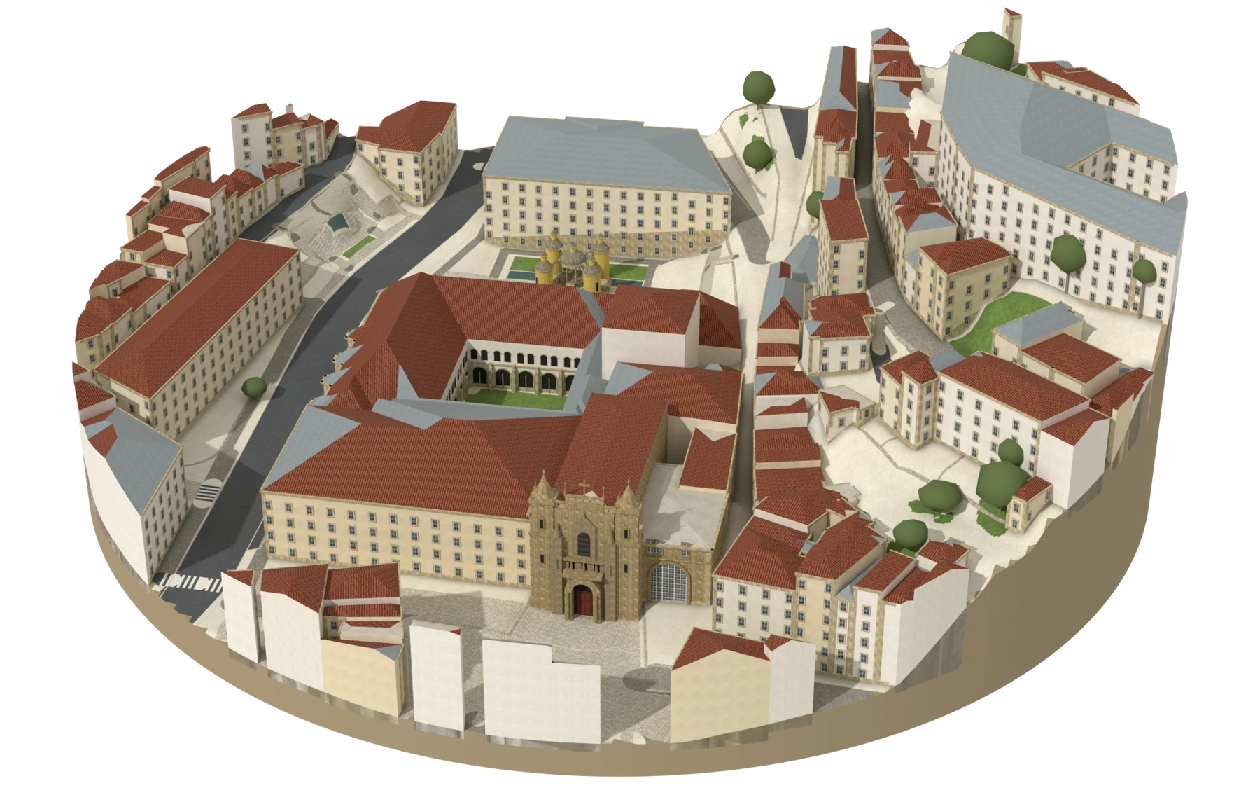
Romanesque cathedral halfway up to the Alta, built when Coimbra was the capital of the kingdom. From outside it looks like a fortress, with battlements all the way round.

First stone in 1162 · National MonumentSé Velha website →
Reconstruction of the Sé Velha and the houses around it, seen from the north-west: the battlemented façade, the Porta Especiosa on the north façade and the lantern tower with its dome; the cloister behind.
  • façades and details: drawn from photographs
  • tile or zinc, as in the aerial photograph
  • streets, squares and gardens: drawn from the map
  • tree
190 m in diameter · lantern tower 28 m high
ModelOpenStreetMap · DGT LiDAR (2 m DTM and DSM) · DGT 2025 orthophoto · 24 Sept 2026
The Alta · Just above the Sé; go down to the cryptoporticus

Museu Nacional de Machado de Castro

The former Bishop’s Palace, standing on the Roman cryptoporticus that held up the forum of Aeminium. The stone galleries beneath the museum can be visited.

Founded in 1911 · on top of the Roman forumMuseus e Monumentos de Portugal →
The history of Aeminium →
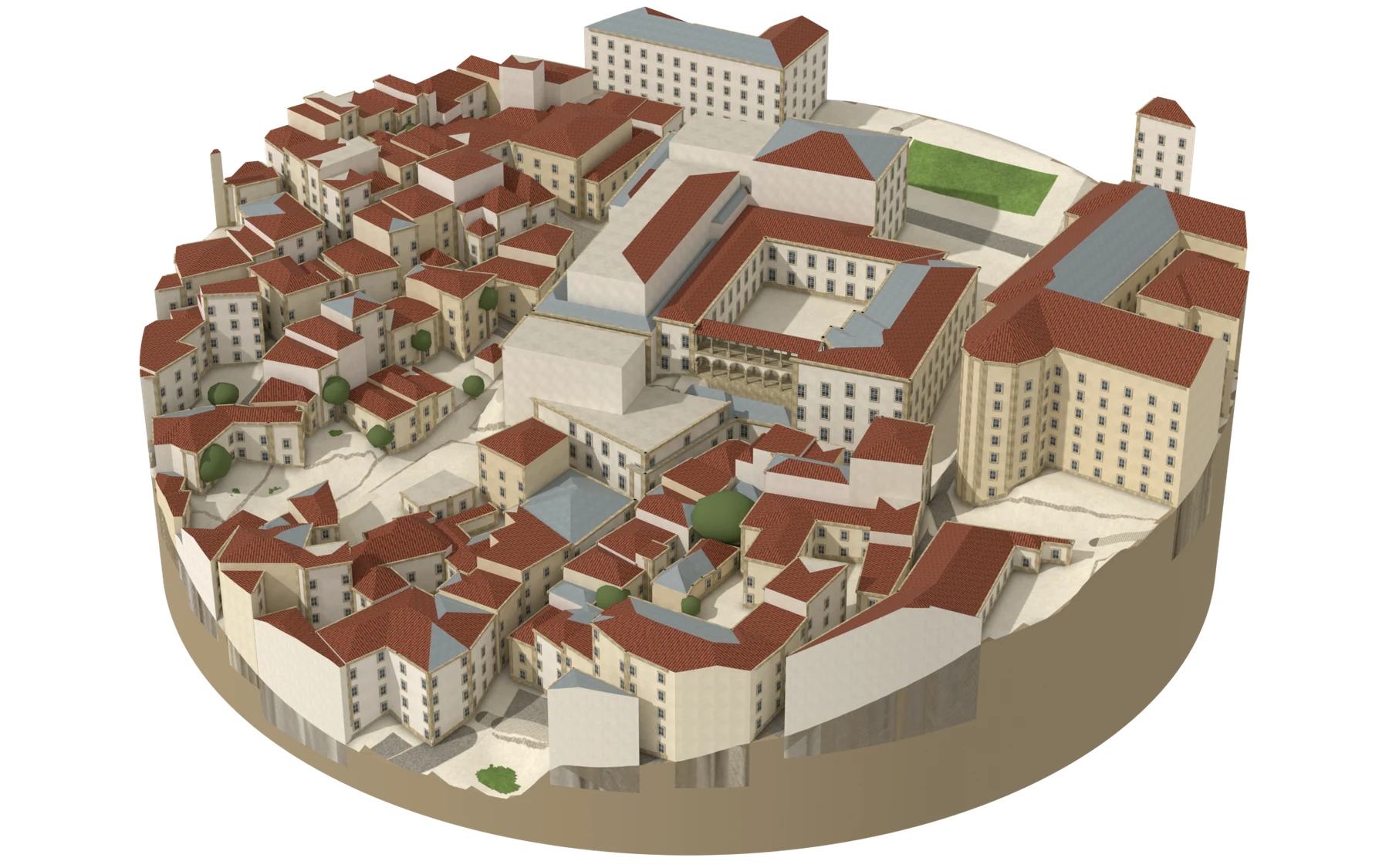
Reconstruction of the Machado de Castro National Museum and the surrounding Alta, seen from the south-west: the terrace and the loggia in front, the courtyard behind, the tall wings to the north and the church of São João to the east.
  • façades and details: drawn from photographs
  • tile or zinc, as in the aerial photograph
  • streets, squares and gardens: drawn from the map
  • tree
180 m in diameter · church of São João 21 m high
ModelOpenStreetMap · DGT LiDAR (2 m DTM and DSM) · DGT 2025 orthophoto · 6 h ago
The Alta · The top of the hill, through the Porta Férrea

Paço das Escolas

The courtyard of the old university, on the site of the royal palace: the Porta Férrea, the Via Latina, the Sala dos Capelos, the chapel and the tower from which the whole Mondego valley can be seen.

University of Coimbra · World Heritage since 2013University visits →
Who visits Coimbra (in Portuguese) →
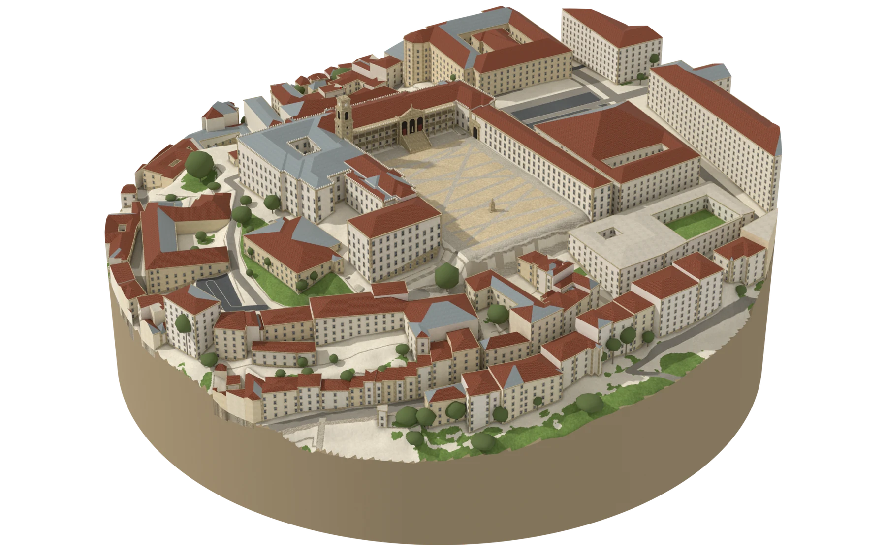
Model of the Paço das Escolas and the surrounding Alta, seen from the south-west: the courtyard open to the valley, the tower at the corner.
  • façades and details: drawn from photographs
  • tile or zinc, as in the aerial photograph
  • streets, squares and gardens: drawn from the map
  • tree
300 m in diameter · tower 34 m high
ModelOpenStreetMap · DGT LiDAR (2 m DTM and DSM) · DGT 2025 orthophoto · 23 Sept 2026
The Alta · In the same courtyard, with a ticket from the university visits

Biblioteca Joanina

The baroque library of the Paço das Escolas: three rooms in a row, lined with gilded bookcases. Two colonies of bats live inside and eat the insects that would eat the books.

Built between 1717 and 1728, in the reign of D. João VUniversity visits →
Midday

Down through the garden

The Alta · East of the Alta, at the garden gate

Aqueduto de São Sebastião

The arches that flank the entrance to the Jardim Botânico, built on the line of an earlier Roman aqueduct.

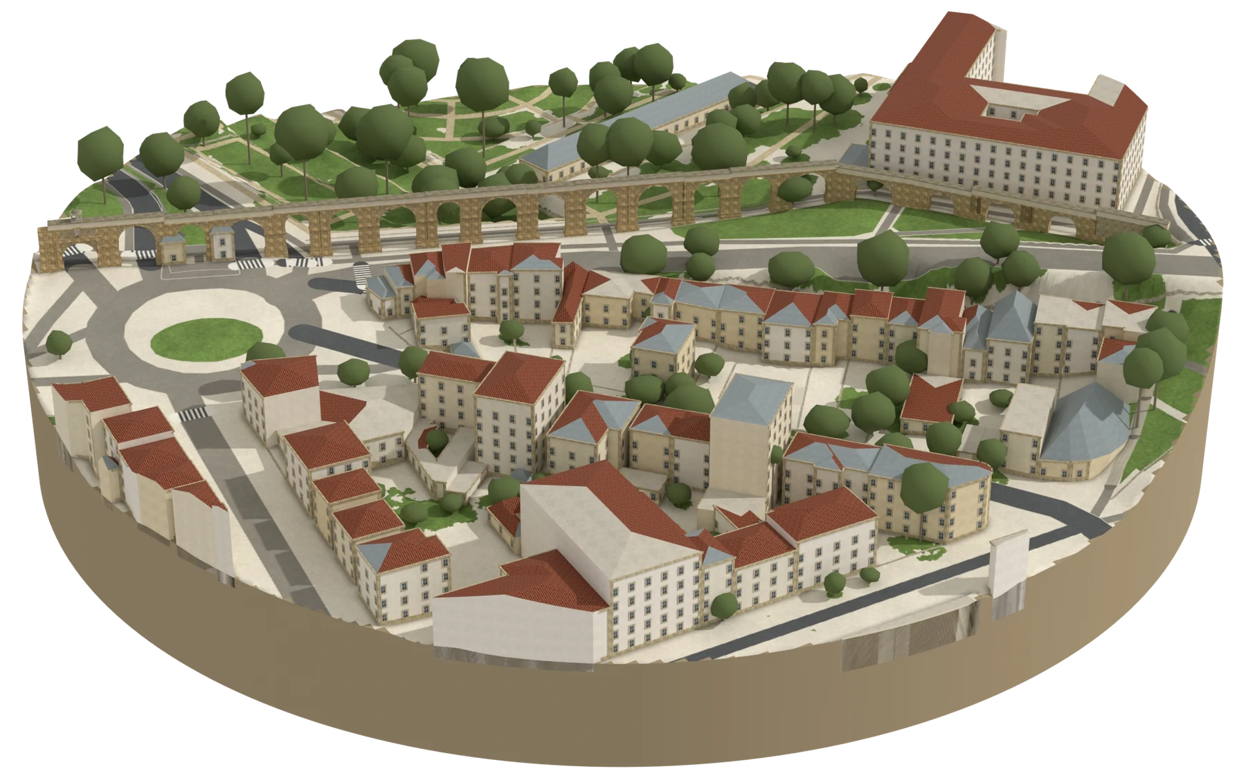
Reconstruction of the Aqueduto de São Sebastião, seen from the north-east: the arcade crosses the model in front of the Botanical Garden, with the Largo João Paulo II on the left and the houses of the Alta in the foreground.
  • façades and details: drawn from photographs
  • tile or zinc, as in the aerial photograph
  • streets, squares and gardens: drawn from the map
  • tree
260 m in diameter · arches 13 m high
ModelOpenStreetMap · DGT LiDAR (2 m DTM and DSM) · DGT 2025 orthophoto · 29 Sept 2026
The Alta · A long break, if the day is fine

Jardim Botânico

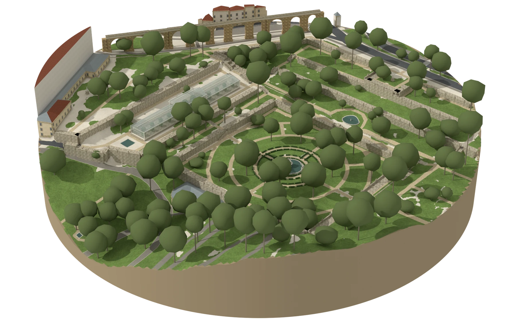
A 14-hectare garden in terraces going down to the valley, with greenhouses, a bamboo grove and the arboretum. Entry to the outer garden is free.

Founded in 1772 · run by the University of CoimbraUniversity visits →
The city’s green spaces (in Portuguese) →
Reconstruction of the formal part of the Botanical Garden, seen from the south-west: the terraces with their retaining walls, the central square with the fountain among the box hedges, the glass Large Greenhouse on the upper terrace and, in the background, the Arcos do Jardim.
  • façades and details: drawn from photographs
  • tile or zinc, as in the aerial photograph
  • streets, squares and gardens: drawn from the map
  • tree
230 m in diameter · Large Greenhouse 10 m high
ModelOpenStreetMap · DGT LiDAR (2 m DTM and DSM) · DGT 2025 orthophoto · 29 Sept 2026
Afternoon

Across the river

The left bank · Over the Ponte de Santa Clara, on the far bank

Mosteiro de Santa Clara-a-Velha

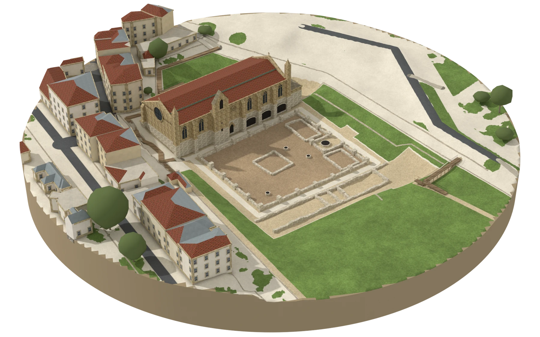
The Gothic monastery that the Mondego flooded for centuries and that was recovered from the mud. It has an interpretation centre with the pieces the excavations brought back.

The river that rose (in Portuguese) →
Reconstruction of the Mosteiro de Santa Clara-a-Velha, seen from the south-west: the Gothic church at the bottom of the excavated pit, with the bell-gable on the south façade and the rose window in the west gable; in front, the ruins of the cloister.
  • façades and details: drawn from photographs
  • tile or zinc, as in the aerial photograph
  • streets, squares and gardens: drawn from the map
  • tree
170 m in diameter · bell-gable 21 m high
ModelOpenStreetMap · DGT LiDAR (2 m DTM and DSM) · DGT 2025 orthophoto · 29 Sept 2026
The left bank · Next to the monastery, especially with children

Portugal dos Pequenitos

The country in miniature, with the regional houses and the monuments at a child’s scale. It is the place in the city that children choose.

Next to Santa Clara-a-VelhaOfficial website →
The left bank · To end the day in the gardens

Quinta das Lágrimas

The historic gardens where legend places the meeting and the death of Inês de Castro, with the Fonte dos Amores and the Fonte das Lágrimas.

Historic gardens · run by the Fundação Inês de CastroFundação Inês de Castro →